Though rectification and everything might be really interesting and useful, I thought today that I might talk a bit about the village economy of the 17th century. This is not only an interesting subject in itself, but also it gives you a better understanding of historical maps from this period. Also, the economy of the 17th century in many ways reflects more or less similar economies in at least the 16th and the 15th century.
We will now travel to the small village of Stjärnholm
The location of Stjärnholm village, to the northwest of Stockholm. If you feel like visiting!
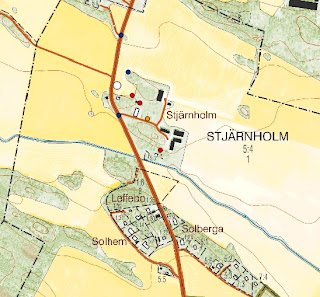
Present-day Stjärnholm, with the locations of the 17th century homesteads marked by red dots. The orange dot indicates a hop-yard, a quite vital part of historical villages which allowed the farmers to brew ale. The blue dots shows unchanged patterns in the landscape. For a change the road can be used as reference points as the junctions have remained the same from the 17th century till today.
17th century map of Stjärnholm, made by surveyor Hans Barckhus in 1688
The first evidence for a village here we find in documents from 1299, where we can find the name “Stiernholm”. Apparently the area have been occupied by farmland for some while when we start our investigation, but it is quite unclear how large the village have been in previous centuries.
The map description, called "Notarum explicatio"
In the document accompanying the map we can see that the village in the 17th century consists of “3 hemman” (marked by the top red ring) which means “3 homesteads”. This tells us nothing really of the number of buildings, as the map might indicate, but should rather be considered as the number of farming, landowning units. The nature of landowning might be different from homestead to homestead. In this village, homestead number 2 and 3 are “frälse” (“noble”) and cultivating land owned by some local nobleman (in a place called “Siöö”) while number 1 is a more special case. This homestead is labelled as “skattekrono” (“taxcrown”, sort of) which means that the land is owned by the farmer himself but he owes interest to the crown. The phenomenon of both noble and royally controlled land in the same village is quite common. How this affected the farmers and their internal relationships is not known and can be discussed.
The next thing to note is the capital letters beneath the red ring (marked by the purple ring). This is a description of the fields and meadows found in the map. Usually it describes the nature of the soil (mud, sand, full of rocks, forest etc.), the size of the area and the annual revenues. Fields were usually farmed in what in Swedish is called “tvåsädesbruk” (two field system) which means that the crops were rotated between two main fields. In this case, the field labelled A was cultivated one year, and B the next year. The small field labelled “C” in the bottom of the map was cultivated annually. In the eastern part of Sweden
Units of measurement in the 17th century were quite different from ours, apparently. The columns marked by the red and the green rings are evidence for this. In the green ring are stated the revenues of each field, measured in tunnor and cappor. Tunnor means “barrels” and 1 “tunna” is the same as the amount of grain gained from 1 “tunnland”. In English “tunnland” is called “acre”, though one acre is 4 047 m² and one tunnland is 4937 m² . Cappor instead is a subunit of tunnor where 32 cappor (or “kappland”) is the equivalent of 1 tunna.
The meadows are measured in sommarlass, which means “summer load” sort of. 1 sommarlass is the same as 213 kilograms of hay. In this case we can see that the village in total has a revenue of 48 sommarlass annually, which equals 10224 kilograms !
Also, these units can vary a lot from area to area. In Uppland for an example, fields are sometimes measured in fjärding which is another subunit of tunnor.
That was all for now, I will continue my visit to Stjärnholm village in later posts!
NOTE:All maps taken from http://www.lantmateriet.se/


Inga kommentarer:
Skicka en kommentar