2013-10-28

MEDIEVAL BOHUSLÄN: On the history of place names

ON THE HISTORY OF PLACE NAMES
   My previous posts (part 1 and 2) have been concerned with a castle ruin called Karlsborg, to the south of Hamburgsund. I have tried to put this rather unexplored ruin into a historical and economic context. More questions have been raised than answered by my investigations, and it is necessary to further explore this castle using both microscopic and macroscopic forms of research. Today, we will be investigating the historic place names of Bohuslän in general, in order to see what this information might tell us about the context of Karlsborg.
   The use of place names in historical research is, according to me, somewhat controversial, at least in more deterministic forms of toponomy. We need to exercise caution when using this information as a base for our interpretations, as it is sometimes difficult to know exactly when a place was named, and why. However, toponomy in Sweden is based on profound research, both linguistic and historical, and it is an intriguing material to use.
   Beneath, I have selected some general elements in place names, from different periods, and tried to analyse their geographical patterns through the use of GIS. As I am quite the novice in the use of place names in historical research, I ask you not to take this analysis too seriously. The material used is heavily generalized, and a closer investigation would be needed in order to use this in more serious research. However, I think that even this shallow analysis have provided me with a nice picture of the historical development of Bohuslän’s settlement patterns.

Prehistoric Place Names

A map showing prehistoric place names in Bohuslän. The white line marks the border of Bohuslän to neighboring counties.
Blue: -by
Purple: -hem
Light green: -landa

According to traditional toponomy, there are certain place names that can be traced back to a pre-christian period. In Bohuslän, these are names ending with either “-by”, “-hem” or “-landa”, e.g. “Svenneby”, “Solhem” or “Kavlanda”. The map shown above is made by selecting present day communities with these elements present in their names. It is clear that “-by” is the most common prehistoric element in Bohuslän’s place names. We should also note, as seen in the map above, that inland Bohuslän is quite devoid of communities with prehistoric place names. This might illustrate that settlements, at least in the late iron age, were shaped by the fact that most arable soils in this region are located close to the coast. We can also assume that these rural communities, though mainly agricultural, also considered fish an important part of their sustenance.

Medieval Place Names

Map showing settlement development in the middle ages. The white line marks the border of Bohuslän to neighboring counties.
Blue: Prehistoric names
Purple: -hult
Orange: -rud
Brown: -röd
Pink: -torp

   Place names from the medieval period in Bohuslän usually contain the elements “-röd”, “-rud”, “-torp” and “-hult”. Most of the medieval names in Bohuslän contain the element “-röd”, referring to cleared ground, and often cultivation. The map above shows a potential development from prehistoric to medieval times, were most of the densely forested area have been colonized. Usually, this phenomenon have been connected to the population growth of the High Middle Ages which, along with technological development, allowed previously quite uninhabited areas to be settled. The initial expansion was halted in the middle of the 14th century, with the outbreak of the Black Death and the following economical decline, also in combination with the environmental change to what have been called “The Little Ice Age”.
   The redoubled amount of settlements seen in the map should not be interpreted as a redoubling of the population during the High Middle Ages. Most of these new settlements were small, lacking the more extensive farmlands found in older communities. Perhaps, we can connect this new settlement pattern to an increased use of the forest itself, but this requires further investigation. Timber was important trade goods in medieval Scandinavia, but whether the settlement expansion in Bohuslän is connected to this, we cannot at the moment tell.   

Karlsborg and Place Names

Place names around Karlsborg
Blue: Prehistoric names
Brown: -röd
Pink: -torp

   This investigation has not clearly shown any connection to the region around Karlsborg. We cannot observe any community name in the immediate area containing the historic elements under study. The closest settlements are Svenneby, Smedseröd, Skogby and Allestorp, all presumably existing simultaneously with the castle and within a 8km radius.. However, they do not indicate any certain importance connected to the location of Karlsborg. This might be explained by the fact that we have excluded many historic places in our investigation (important places such as Dynge, Apelsäter, Hallinden and Vettland are not included), where we have sought a general pattern rather than interesting particularities. More local place names, among them the names of rivers and natural features, should be taken into account when conducting a more localized analysis.

   If we ignore the above criticism, however vital it may seem, we can assume that the region was not particularly important or special in the High Middle Ages, and that the importance can be connected to the later middle ages. Many of the place names in the investigation above defines settlements founded in the initial expansion of the earlier middle ages, and the pattern may have changed during the later middle ages. If the area around Karlsborg had been previously unimportant, it would explain why the site was not extensively fortified until the middle of the 15th century. This, at least in a very generalized way, supports the idea of seasonal fishing, caused by a herring period, as a foundation for the importance of Hamburgsund and Karlsborg. While written history does not support this theory, it is not unlikely. Maybe be the lack of documentation of this period can be traced to a high degree of international activity in the area. More on this in coming posts!


   That was all for now! As usual, you are more than welcome to share your thoughts and ideas on the topic discussed. If you found this post interesting, feel free to leave a comment!

2013-10-14

Karlsborg: A castle by the sea pt.2

KARLSBORG: A castle by the sea pt.2

Some thoughts on Seasonal Fishing
  In my last post, I introduced the ruin of Karlsborg castle, just south of modern day Hamburgsund. We explored the archaeological features of this castle, mainly through LIDAR data, and did a summary of what historical sources can tell us about this place. It seems like this was an important location, at least in the late middle ages and the early renaissance. Both Swedish and Danish kings obviously had an interest in controlling the area, and Karlsborg castle.
In this post, I am going to discuss the role that seasonal fishing might have played in defining the importance of this region. Using data from FMIS (Fornminnesregistret = lit. the register of ancient memories (ancient monuments)), we will explore what traces this activity left in the landscape.

   Bohuslän have, at least in more recent centuries, long been associated with the fishing industry. The herring periods brought economic development to this otherwise quite marginalized area. Historical sources indicate that the fishing of herring was common already in the 11th century, and from Vestlandet (Western Norway) and Viken (the earlier name for Bohuslän) herring was exported to Germany and England in the late 12th century. However, it was not until the late 16th century that this fishing reached larger and more important proportions. From the middle of this century, fishermen from other parts of Denmark (which then included Norway) came to the coast of Bohuslän, establishing seasonal fishing settlements where they stayed from autumn till late winter. The large amount of herring that were drawn to Bohuslän during this period also attracted fishermen from abroad, both from the Baltic area and from North-western Europe. The city of Marstrand, located just north of Gothenburg, became a centre for international herring trade. Permanent coastal fishing stations were also established during the late 16th century, marking a change in habitation from earlier centuries. The herring period of the 16th century lasted for 40 years, after which the activity in the area ceases quite abruptly.

 Picture showing some typical examples of what a "tomtning" might look like. Photo from: Bohusläns Museum.

  The type of seasonal fishing settlements discussed above are called “tomtningar” (singular = “tomtning”) in Swedish. These are features usually found in connection to beaches of different kinds, identified by a low stone wall enclosing a space usually about 1-10 meters wide. While there are some inland examples, almost all tomtningar are located on islands. The geometrical shape of a tomtning may vary from circular to quadratic. It is not unusual that several of these features lie side by side, like a row house. Archaeological investigations have shown that tomtningar usually can be dated to a period between the 13th - 16th centuries. Investigations on Söö island, south-west of Gothenburg, have also shown that bones from cows and sheep are commonly found in these features, indicating that fish were considered important trade goods, and not meant for personal sustenance. In addition, English coins dating to the 13th century have been found in tomtningar on Söö island, indicating the presence of international fishermen.

A map created in ArcGIS showing remains in the area related to the sea and fishing. You will see this map again in coming posts, but for now we are mainly concerned with "tomtningar". Click for larger picture.

  We can see, in the map, that there are 23 tomtningar on the islands outside Karlsborg. From the above material, we can assume that at least some of these are from the active period of the castle. But does this really give us a clue to the importance of this region? Why would Kings care about this?

  According to medieval law, all local inhabitants had the right to use the beach for their boats, nets and to bring up the catch. But the King owned all land defined as “Forstrand” (foremost beach?). What is meant by this is somewhat unclear, though a common interpretation is that the king owned a part of the beach, and presumably all islands without a farming population. The King would then be the only person with the right to allow fishermen from other parts of the kingdom and abroad to use these islands and beaches for seasonal fishing. We can also assume that this would give him the opportunity to collect tax from these fishermen, thus increasing his revenues and giving him control of international trade. 

 A Point Density analysis done in ArcGIS showing the geographically dense areas of "tomtningar" in the County of Västra Götaland. Click for larger picture.

  The Point Density Analysis of Tomtningar in the county of Västra Götaland shows that the area just north of Hamburgsund is an area with a large amount of tomtningar, an amount only bested by denser concentrations in the archipelago outside of Gothenburg. While tomtningar in the area of Gothenburg have been the focus of some research, the concentration found to the north of Hamburgsund and to the west of present day Fjällbacka, have been largely ignored. In my opinion, this concentration, in relation to the political history of the area, can provide a plausible explanation for the importance of Karlsborg.

  This, however, must be explored on a deeper level, especially as we cannot give a definite dating for these seasonal fishing settlements. Given the archaeological investigations in other areas, we can presume, but not of course be entirely sure. We have to delve deeper into the historical and geographical characteristics of this area, in order to see what other features that define the region. For this, see my upcoming posts!
  Till then, I would very much appreciate my readers insight and ideas. Here are some questions I would like to raise:
  • What do you think of the above theory?
  • Would the prospect of economic revenues be enough motivation for controlling this specific area?
  • Why were the islands north of Hamburgsund, as compared to other areas in Bohuslän, so dense in seasonal fishing?


FURTHER READING (Sorry, most of it's in Swedish)

Ersgård, L. (2001). Människan vid kusten – fiskebebyggelse från Skagerack till Bottenhavet under senmedeltid och början av nyare tid. In Andrén, A., Ersgård, L. & Wienberg, J. (ed.) (2001). Från Stad Till Land: En medeltidsarkeologisk resa tillägnad Hans Andersson. Almqvist &Wiksell Internation: Stockholm.

Svedberg, V. & Jonsson, L. (2006). Medeltida urbanisering och fiske i Västsverige. Göteborgs universitet: Nossebro.

Stibéus, M. (1997). Medieval Coastal Settlement in Western Sweden. In Andersson, H, Carelli, P. & Ersgård, L. (ed). Visions of the Past: Trends and Traditions in Swedish Medieval Archaeology. Lund Studies in Medieval Archaeology 19. Riksantikvarieämbetet, Arkeologiska Undersökningar, Skrifter nr 24. Lund.

Stibéus, M. (2004). Medeltida Tomtningar På Söö. UV Väst rapport 2004: 35 
Link to this report, here

2013-10-05

Karlsborg: A castle by the sea

KARLSBORG – A CASTLE BY THE SEA 


Just south of Hamburgsund in Bohuslän lies a place commonly known as “Slottet”. This is in an area nowadays mostly inhabited by summer guests, due to the exclusive attraction of Bohuslän's extensive archipelagos. In summertime, this area is full of life, but during the long and harsh winters only a few natives remain. This is nothing new, really, as the coast of Bohuslän have been inhabited seasonally in the past as well, especially during the herring periods of the 16th, 17th and 18th centuries, when seasonal fishing stations where formed on the islands and the coastline. But perhaps, in more distant times, this area was much more active. This can be seen by the many archaeological traces left in the landscape, where we especially can discern a rich Bronze Age culture. Among other things left from this period, we find a large amount of rock carvings and cairns (“röse” in Swedish) in the area close to Hamburgsund and Slottet. But it is not these highly interesting Bronze Age remains that we shall discuss now, but rather the traces of historical times, of the medieval and early renaissance activities in this area.

The beautiful view from Karlsborg, where you can see a part of the earth-works in the foreground. The actual walls of Karlsborg were probably wooden palisades, for which the earth-works that remain served as a foundation. Photo taken from: wadbring.com

The name “Slottet” is derived mainly from a ruin on a small mountain just by the southern cove leading into the modern community of Hamburgsund. This mountain is surrounded by steep cliffs on all sides, except in the west where what could be either a natural or a humanly constructed ( though quite steep) slope leads up to the top, where the ruin is situated. In modern times, a staircase has been built on this slope, enabling less fanatical visitors to access the ruin as well. When I mention “ruin”, most people would expect this to be a sort of “classical” castle ruin, with clear remains of walls, towers etc. This is not the case. All that remains are some earth-works surrounding the top of the mountain, and for the trained eye it is also possible to detect the remains of what could be two barbicans (“förborgar” in Swedish) in the slope.
An archaeologist named Wilhelm Berg excavated the castle in the early 20th century. Among the artefacts where the backside of a canon, canon balls, gun bullets, points from arrows, crossbow bolts and lances. While these artefacts point to military functions, we can of course not depend entirely on the inadequate documentation and excavation methods from this early period in the history of Archaeology. Nevertheless, these findings are interesting.

A Digital Elevation Model made with LIDAR data. The two potential barbicans are marked with blue rings, and the path up to the top is marked with green. The blue area roughly corresponds to the sea level of the late medieval period. Note the highly visible earth-works that surround the top of the mountain, and the iron age mounds visible where the path starts.


According to written history, the proper name for this castle ruin is “Karlsborg”, and was fortified in 1455 by the marshal of Sweden, Tord Bonde. Entire Bohuslän had in 1455 been taken by the marshal on king Karl Knuttson Bonde's orders, and Karlsborg was built in order to gain control over the fairway between Denmark and Norway, which passed the islands just outside Hamburgsund. However, Tord Bonde was murdered in 1456 by the castle's bailiff, a Dane called Jösse Bosson. After this, Sweden lost control over Bohuslän to the Union (at the time between Denmark and Norway). During the reign of Gustav Vasa, northern Bohuslän was attacked by Swedish troops once more in the 1520s. Karlsborg was restored to it's former glory in 1525, after which the castle became the administrative centre of the region. This secured the connection of Sweden to the North Sea and the trade routes to England and western Europe, if the estuary of Göta Älv, close to present-day Gothenburg, had been ceased by the Union. In 1531, the castle was attacked and razed by the troops of the former Danish king Kristian II ( known in Sweden as “Kristian the Tyrant”), and the castle was never restored again.

The location of Karlsborg in Hamburgsund's strait.

That was all for now! In the next post, I will use further GIS analysis to investigate why this place was so important. Karlsborg obviously played an important role in controlling Bohuslän, but there is no clear urban central place in this region, from this period. I will use a mainly quantitative geographical material, through a long-time perspective, to see if we can find some clues. Till then, I hope you have enjoyed this brief introduction to a very interesting site!

2013-06-20

Historical Geographical Databases: An Introduction to GEORG

 Among the current developments in archaeology, history and geography the Digital evolution is by far the most significant one. The digitalization of historical information is a recurrent theme in projects at archives, museums and universities. Geographically bound data makes it possible to conduct larger studies at a previously quite inaccessible scale, and the importance of a geographical focus, not the least in the building of easily searchable databases, is clearly something that have recently been realized by several institutions. The use and the ongoing development of GIS software have contributed much to this movement. Alongside with the digital evolution there have also been a lot of discussion about the public accessibility of digital information. That is, the “free or not free” part of this data. Among the people working with open source software this is something almost religious, where all data should be downloadable for free. In other cases, especially where the data can be used for commercial purposes, the data is often (at least partly) available to view, but only downloadable for “premium” members (which means that you have to pay). 

Today, I will introduce you to a Swedish database named GEORG, the elder sister of the database KARL that I have contributed to this spring. See my earlier posts for more on KARL and the project YGK.


GEORG is a complex database built mainly for researchers. Here we see some of its basic functions such as "Show map collections", "Search register and export" and "Search by map"

GEORG is the result of a project named “Nationalutgåva av de äldre geometriska kartorna” (National edition of the elder geometrical maps). This project had its base at the National Archives in Stockholm and was led by Clas Tollin, docent at the department of agrarian history at SLU in Uppsala.  The project lasted between 2001-2010 and the goal was to make the information in the geometrical maps from 1630-1655 easily accessible to researchers and other interested individuals. This meant that the maps, previously scanned in quite poor quality, had to be rescanned in high quality and all the information had to be geographically registered with the use of GIS. In addition, all the written text describing the maps were transcribed and digitalized. The maps themselves follows almost the exact same pattern as the Younger geometrical maps, which I have described in detail in earlier posts. The result is a database where all the data is accessible and downloadable. At the moment, the site is only available in Swedish, though an English translation is planned.

This database was among the first of its kind, and a landmark in the evolution of geographic historical databases. At the present there are many projects going on using many of the same principles. For readers fluent in German there is a highly ambitious project going on in Pomerania, which in the 17th century was a part of the Swedish Empire. For readers more comfortable with English than these other languages I can recommend you to look at the database for the Down Survey of Ireland, which can be compared to GEORG. This database is also concerned with 17th century maps, though the material is quite different. Links to these projects can be found below.
  
That was all for now. Please, feel free to send an email to oscarjacobsson@live.com if you have further questions!


GEORG:


Svea Pommern:


Down Survey of Ireland:

2013-04-30

A VISIT TO A 17th CENTURY VILLAGE part.2: Homesteads and Outfields


Today we are going to investigate the village of Stjärnholm once again, this time focusing on the homesteads themselves and the information we can find about them in Notarum explication. For more about this village, please read my earlier post!

 The village of Stjärnholm, with the homesteads marked


Notarum explicatio

  The first thing usually described on each homestead is the name of the farmer. These names are very common even today, and almost all of them have surnames ending with “-son”. In this particular village we have two farmers (in homestead 1 and 3) surnamed “Larsson”. We cannot be sure that these two are related to each other as this is a common surname, but as they inhabit the same village it is quite likely.
   After the names comes the land owning nature of the homestead, such as “krono”, “skattekrono”, “frälse” etc. If the land is “frälse” (owned by a noble) sometimes the name of the nobleman/woman or the estate is noted.
   The third thing described is the value of the farmers’ land in the unit “öresland”. Öresland is a unit that does not necessarily describe the amount of land; it can also be a description of the revenues. The exact meaning of this unit seems somewhat uncertain depending on what area you are investigating. In Uppland, there seems to be a quite clear correlation between öresland and tunnland. In the YGK-project we are converting all land values into the same unit, called penningland (1 öresland is the same as 24 penningland) which is more common in this period. This is done in order to make the statistics from various areas comparable with each other.
   After this, the annual revenues of the homestead are described. Each homestead usually use the two field system and therefore the revenues are described for each year of farming.
   Under the revenues, you can sometimes find information on areas used by the farmer which lie outside the village (in Swedish “utjordar”), often in a neighbouring area. Sometimes the revenues for these patches of land can be found in the homesteads description, but most of times this is described in another map, if such exists. More on this below.
   Another thing to note here is something found above the description of the homesteads. We can usually find information here about the outfields (though it is not really fields) of the village. The outfields or the “outlands” (perhaps a better term) of a village are usually used for grazing, gathering of firewood, fishing and some hunting. Outlands are usually not described in detail, but the quality is defined by terms such as “good fishing” or “almost no firewood at all”. In this case we can read that the outland of Stjärnholm consists of bare ground which provides poor grazing.

Now we will investigate the homesteads:    

Homestead number 1: This is a ”skattekrono” homestead inhabited by Erich Larsson. The farmers’ land is worth 14 öresland (336 penningland). We can see that one year the revenues of the farmed field are 12 tunnor and 11, 19/87 cappor. Next year the revenues are 9 tunnor and 19, 3/87 cappor. The surveyor has calculated the mean value of the revenues from these two years and written down the result in the row to the right. To calculate the total area of the fields we simply have to multiply the mean value by 2 (as this is a two field system). The result is: 21.945 tunnland. The meadows bring in 15, 39/87 sommarlass of hay each year.
This farm also owns three patches of land in other areas. Specifically these areas are: “Wreeta”, “Fänsgiärde” and “Fittja parish”. If these areas are mapped or not we cannot at the moment know. All that can be said is that they do not exist in the same volume of maps (named A16).

Homestead number 2: This is a “frälse” homestead inhabited by Johan Mattzon. The farmers’ land is worth 14, ¾ öresland (354 penningland). The mean value of the revenues is: 11 tunnor and 17, 163/174 cappor. This means that the farmed fields are 23.121 tunnland. The meadows bring in 16, 24/87 sommarlass of hay each year.

Homestead number 3: This is a “frälse” homestead inhabited by Johan Larsson. The value, fields and meadows are the same as number 2. Here it is also noted that number 2 and 3 have common land in an area called “Fänsgärde”.


In short:

Homestead   Owning         Fields(tunnland)                 Meadows(lass)            Value(pen)
1                    skattekrono    21.945                                 15.448                           336
2                    frälse              23.121                                 16.275                           354
3                    frälse              23.121                                 16.275                           354


That was all for now. Hope you have enjoyed your visit to Stjärnholm village!

NOTE:
All maps taken from http://www.lantmateriet.se/

2013-04-26

A VISIT TO A 17th CENTURY VILLAGE part.1: Landowning and measurement units

   Though rectification and everything might be really interesting and useful, I thought today that I might talk a bit about the village economy of the 17th century. This is not only an interesting subject in itself, but also it gives you a better understanding of historical maps from this period. Also, the economy of the 17th century in many ways reflects more or less similar economies in at least the 16th and the 15th century.
We will now travel to the small village of Stjärnholm!

The location of Stjärnholm village, to the northwest of Stockholm. If you feel like visiting!


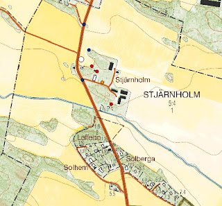
Present-day Stjärnholm, with the locations of the 17th century homesteads marked by red dots. The orange dot indicates a hop-yard, a quite vital part of historical villages which allowed the farmers to brew ale. The blue dots shows unchanged patterns in the landscape. For a change the road can be used as reference points as the junctions have remained the same from the 17th century till today. 


17th century map of Stjärnholm, made by surveyor Hans Barckhus in 1688


   The first evidence for a village here we find in documents from 1299, where we can find the name “Stiernholm”. Apparently the area have been occupied by farmland for some while when we start our investigation, but it is quite unclear how large the village have been in previous centuries.

The map description, called "Notarum explicatio"


In the document accompanying the map we can see that the village in the 17th century consists of “3 hemman” (marked by the top red ring) which means “3 homesteads”. This tells us nothing really of the number of buildings, as the map might indicate, but should rather be considered as the number of farming, landowning units. The nature of landowning might be different from homestead to homestead. In this village, homestead number 2 and 3 are “frälse” (“noble”) and cultivating land owned by some local nobleman (in a place called “Siöö”) while number 1 is a more special case. This homestead is labelled as “skattekrono” (“taxcrown”, sort of) which means that the land is owned by the farmer himself but he owes interest to the crown. The phenomenon of both noble and royally controlled land in the same village is quite common. How this affected the farmers and their internal relationships is not known and can be discussed.

   The next thing to note is the capital letters beneath the red ring (marked by the purple ring). This is a description of the fields and meadows found in the map. Usually it describes the nature of the soil (mud, sand, full of rocks, forest etc.), the size of the area and the annual revenues. Fields were usually farmed in what in Swedish is called “tvåsädesbruk” (two field system) which means that the crops were rotated between two main fields. In this case, the field labelled A was cultivated one year, and B the next year. The small field labelled “C” in the bottom of the map was cultivated annually. In the eastern part of Sweden, the two field system was the most common system of crop rotation until more modern ways of cultivation replaced older ones.
   Units of measurement in the 17th century were quite different from ours, apparently. The columns marked by the red and the green rings are evidence for this. In the green ring are stated the revenues of each field, measured in tunnor and cappor. Tunnor means “barrels” and 1 “tunna” is the same as the amount of grain gained from 1 “tunnland”. In English “tunnland” is called “acre”, though one acre is 4 047 m² and one tunnland is 4937 m². Cappor instead is a subunit of tunnor where 32 cappor (or “kappland”) is the equivalent of 1 tunna.
The meadows are measured in sommarlass, which means “summer load” sort of. 1 sommarlass is the same as 213 kilograms of hay. In this case we can see that the village in total has a revenue of 48 sommarlass annually, which equals 10224 kilograms!
Also, these units can vary a lot from area to area. In Uppland for an example, fields are sometimes measured in fjärding which is another subunit of tunnor.

That was all for now, I will continue my visit to Stjärnholm village in later posts!   NOTE:All maps taken from http://www.lantmateriet.se/


2013-04-17

Rectification results!

Here are some results from a rectification I just did, using the methodology described in the last post. The map in the last post did not give a good result, as it was heavily distorted by the surveyor whom I now actively distrust. ;-)
But the map in the last post illustrates some of the key problems in rectificating these old geometrical maps. As a result of their instruments and methods, the surveyors only had limited possibilities to cover a whole area, escpecially from one position. The surveyor had to change position (from where he was measuring and triangulating) several times during his work. Features of real importance were usually measured from a close distance and this is why the maps are more accurate inside the actual boundaries (in swediish called "hängnad") of the farming lands. Outside these boundaries the maps are sometimes quite distorted or innaccurate, so caution must be observed. Furthermore, some surveyors were apparently MUCH more accurate than others. A man named Jacob Braun, whose maps I am currently quite engaged with, appears to have made a good effort in making accurate measurements over long distances.
What does this mean for we who are rectifying? This means that even if we identify key common features in the map, it might sometimes be so heavily distorted (especially in the edges) that a good rectification is almost impossible. The people I'm working with are somewhat more up to date on this matter, so I'll be giving you more information on how to confront this problem in the near future.

Here is another case study, with one of Jacob Braun's maps. :) The result proved quite good, considering that is almost only just an overlay and the map is really old.


A map of Hässle manor in Fittja parish, Uppland. Done by Jacob Braun in 1690.


A modern day topographical map of the same area. The features in the map have all been added manually by measuring and triangulating in the old map. Only three georeference points were added, marked by the smaller red dots.


The rectified result, sorry for the bad quality. The transformation type I used is called Helmert, and basically only scales and rotates your picture. You can see almost all the marked features smoothly aligning with the historical map, with just a slight distortion. Most of the topography fits surprisingly well, as well. 


That was all for now, stay tuned for more on this exciting subject!
 
 
NOTE:
All maps taken from http://www.lantmateriet.se/

2013-04-15

On Historical Maps and Rectification


The rectification of historical maps is a commonly used tool for understanding landscapes and archaeological sites. It is often used by contract archaeology to determine the location of potentially interesting features. By landscape archaeologists rectification is used to make landscape analysis in order to recognize certain changes. But while this tool is effective and easy to use in most GIS softwares it is by many geographers considered to shallow and inaccurate. The rectification often stretches the original map to a point were the historical surveyors’ measurements are no longer valid. It is true that historical maps may be inaccurate, but most of times they are surprisingly well made, as discussed below. Therefore it should be considered whether stretching of original maps is a good way to work or not. The accuracy of the surveyor must always be taken into account. Also, rectification does not often promote an actual understanding of the map, it merely tries to force common points without too much thought. I have chosen to take the perspective of the geographer in this, and the method described below shows another good way of working with historical maps and in turn rectification. Most of this is based on the methodology of the project I’m currently working on dealing with 17th century maps from Sweden. If you want to know more please visit http://www.riksarkivet.se/default.aspx?id=21561&refid=22519 or send me an email!

   First we must recognize the parts of the map that have not changed for 300 years or so. Many times roads are used for rectification of historical maps, but these are in my opinion quite uncertain elements and it is possible that they have changed a lot during the centuries. This also applies for humanly created features like farmsteads, bridges and sometimes also large manors and churches. The only humanly created feature that can be used as points of rectification with a quite good accuracy are the administrative borders found in historical maps. These are quite surprisingly often still used today and although some changes have been made it is usually not a very hard task to recognize parts that are unchanged. Otherwise, it is usually the natural topography that gives us a hint of common points. Mountains and rocky parts of land were usually not cultivated in the 17th century, and are commonly still not cultivated today. In the map of Hammarby, we can see such a large patch of land just northwest of the village itself. Also, to the direct southeast of the village there is a perhaps more useful round patch in the farming fields (marked by green ring, bottom left corner of present day map). Just south of the label Backgården there is another fairly certain point (marked by the blue ring).


A 17th century map of Hammarby in Uppsala county. The village is at least medieval and fairly large, though its exact origin remains quite uncertain.


A modern day economic map of the same area. The positions of the farmsteads in the historical map are marked with red points

   It is surprising how accurate the some 17th century Swedish surveyors actually were. It is usually said that they were the most accurate with the actual fields and within the boundaries of the farmsteads, but in measuring in the actual map itself it is proved that their abilities went far beyond that. Of course, this depended on the surveyor himself, as some were much more accurate and detailed than others.
As a result of this relatively high accuracy it is usually possible to use the scale bar (marked with a red ring in the picture) found in the historical map itself to make measurements. In the 17th century maps of Sweden, the units are measured in “alnar”. 1 “aln” is the same as 59.3 centimetres and a good way to start is by converting the scale bar into modern units. This can be done easily with the program DjVu viewer (http://www.djvuviewer.com/) if your file is in djvu format. Otherwise, though perhaps more complicated, you can probably reach the same result using your GIS software or CAD. In doing this you can calculate the relative accuracy of your particular surveyor by measuring distances between topographical features and boundaries, both in the historical and the present-day map.

   After this procedure you can use the common points in topography and administration described above to triangulate the position of features of interest in the historical map. Usually it is enough to take two measurements in the historical map, from the common point in the landscape to the feature. When these two measurements correlate from the same points in the present-day map you are usually quite close to your feature.

   To give support to the position of your features it is usually a good thing to consult your country’s record of monuments and sites. In Sweden, the online database called FMIS is a good resource for validating your results. Also, as it is always good to use multiple sources, you should also consult more recent historical maps. In the case of Hammarby I used an economic map from the 19th and early 20th centuries called “Häradskartan” were some of the old features still remain. Fields and topography are also more easily recognized. These historical yet quite recent maps are usually considered a bridging point between older and present day maps.

How these points can be used in making a rectification must still await a complete evaluation, but they should at least provide more valid information on the position of the mapped features. In this particular map, for an instance, I have only put a few points in the centre, which would not be a good base for rectification of the complete map. This is rather another way of recognizing common features in the maps. In order to make a good rectification I would need to use the whole of the quite extensive map, which is not possible at the moment, sadly. I will come back with a rectification result when I have gathered enough data to do so. Until then, I hope that my geographers perspective have proved inspiring!

NOTE:
All maps taken from http://www.lantmateriet.se/

2013-04-07

Work placement at the national archives

WORK PLACEMENT AT THE NATIONAL ARCHIVES
 
 
This week I started my work placement at the national archives in Stockholm, Sweden. I am currently working as a trainee in a project called “Yngre geometriska kartor” (Younger geometrical maps). We are working with the digitalization of Swedish maps dating from the 17th century, putting coordinates on features found in the maps (like houses, mills, barns, bridges etcetc.) and making statistics of the mainly economical information found in the map descriptions. All the maps and the connected information are made publicly available through an online database called GEORG. For anyone interested in the historical geography of Sweden this provides a wealth of information previously rather unavailable. The landscape found in this maps have much older origins than the 17th century and conclusions about for an example medieval landscapes can be drawn from them. This is extremely exciting and I will keep you updated on the progress of our work this spring.


A map of Österby manor in Uppland from 1688 by a quite good cartographer named Petter Arosander, which I had the oppurtunity to register this week. The manor itself seems to have been replaced by a more modern one in later centuries though the foundations must still remain. The location of the church ("Ålands kyrka") in the northwest corner of the map remains intact. This was founded in the 15th century. The church village represented by the lonely house (the rest of the older village is located just west of the river) close to the bridge have even older origins and the name Åland can be traced to the 13th century.

Here’s a link to the now finished project about the “Older geometrical maps” which maps dates to the start of the 17th century. The material is already available for the keen researcher to use. Basic knowledge in Swedish is required, however.


2013-03-19

The Study of Medieval Townscapes, Part 2


FERNAND BRAUDEL - La Longue Durée and Multidimensional timeframes

   In the year of 1958 the French historian Fernand Braudel published an article by the name of La longue durée which has had an huge impact on the discipline of history. Braudel was undoubtedly one of the twentieth century’s most influential historians and as he promoted a certain geographical focus it could be interesting to investigate the application of his theories unto an urban material.

   According to Braudel, time moves in different ways and he divides time into three different timelines. The first, and the most central to Braudels history, is La longue durée the most tough and slow of the three timelines. La longue durée is the aspects of the human world that was almost unchanging in character and form, where change only can be created from long periods of time. This timeline is characterized by different structures, a structure being those created phenomenon and constellations that have almost completely withstood the test of time. Geographical relationships are a good example of this, where nature and climate have formed the possibilities and boundaries of human life. The second timeline is the Economic and Social one, which is faster in changing yet still moving so slow that changes not necessarily will be recognized during a persons lifetime. The third and fastest timeline is the time of Politics and Events, what Braudel called “quick history”. This third timeline is not concerned with surroundings and larger contexts (Elgán, E. 2010:740-43).

   Braudel was but a part of a larger movement, mostly based in France, called the Annales School. Of the persons involved in this movement, Braudel became undoubtedly the most famed and influential. La longue durée was central to the Annales School and history according to them was not entirely determined by humanity. External forces such as geography and climate have a huge influence on the formation of human society, and it is therefore vital to study these themes in combination with for an example politics and economics (Trevor-Roper 1972:470-71).

   Before Braudel, historians had mainly studied the “quick” history or histoire événementielle. This was still central in the work of Braudel and the Annales school, was so to speak just the “tip of the iceberg”. The multidimensional history described above had yet been quite unexplored and required a total multidisciplinary approach. This was quite revolutionary around the 60s and enabled previously quite “dead” material to be studied once more through an other perspective (Trevor-Roper 1972).

   What potentials are there in studying medieval urban society in the manner of Braudel and his fellows? This is an interesting question and various researchers have through the years applied the perspective of la longue durée to medieval material. I am not yet up to date on how much influence Braudel has had on the discipline of archaeology, but I recall a comment on the matter in Kristina Carlssons doctors thesis Var Går Gränsen? (2007) and it cannot therefore be totally non-existent. Of course, it could be argued that Landscape Archeology in general is concerned with the structures of la longue durée but as we have said the wider scope is paradoxically rather ignored and so are the long timeframes especially in historical landscape archaeology. As a postmodernist would argue: Historical archaeology does not necessary have to be confined to historical timeframes, which indeed are modern constructions and not absolutely related to a past way of thinking. It could therefore be interesting to study the location of towns in a long-time perspective, say for a 1000 years or more. The location of prehistoric settlements for example in relation to medieval ones, could provide interesting information into possible continuity or discontinuity.

   What locations are people drawn to and why? This is an interesting question to which many levels of study can be applied. Braudel tempts us to study how the geography of an area could have influenced human settlement and for someone with a quite environmental deterministic approach such as me it is tempting to merely study how settlements relate to natural phenomenon such as rivers, mountains, forests etc. But Braudel did not argue for just focusing on these types of la longue durée, and we must not confine ourselves to one dimension of time. We need to be multidimensional. Especially in studying urban areas, it is important to recognize the fact that geography is not merely nature, it is also human. A location may be attractive not only because of the proximity to an ocean, but also because of symbolical meanings imbued upon the land or of humanly created geographical factors such as borders. Urban studies should therefore not seek one single reality (as there may have been several, depending on scope and through whose eyes we are watching) and Braudel gives us the means to apply several realities through the application of multi-dimensional timeframes.


REFERENCES:


Elgán, E. (2010). Fernand Braudels artikel “La Longue Durée” och svensk historieskrivning idag – några reflexioner. I Historisk Tidskrift 130:4

Länk: http://www.historisktidskrift.se/fulltext/2010-4/pdf/HT_2010_4_739-749_elgan.pdf


Trevor-Roper, H.R. (1972) Fernand Braudel, the Annales and the Mediterranean. In Journal of Modern History, Vol 44, No. 4. Chicago Press. Ss. 468-79

2013-02-18

The Study of Medieval Townscapes, Part 1

THE STUDY OF MEDIEVAL TOWNSCAPES, PART 1 – Some thoughts about the English landscape tradition

There are many different methods and theories that are popular in the study of medieval towns and their natural context. The subject is not limited to a single discipline, but is multidisciplinary in its nature and can be approach in a great variety of ways. As this blog is concerned with medieval landscapes it could be interesting to raise a few questions putting the study of urban settlements into the context of landscape studies as a whole. We will start by exploring a bit the Historical English Landscape Tradition which has dominated much of European studies of historical landscapes.


   My previous studies have mostly been focused on British material, where we actually find quite a gap in literature and articles discussing the natural context of medieval towns. This is mostly a result of the historical geographical heritage in England in which English landscape archaeology and landscape studies in general have their roots. This particular branch of study is commonly known as “the English landscape tradition”. The English landscape tradition is mostly in methodology based on the works of geographer W.G. Hoskins and archaeologist O.G.S. Crawford and as studies of urban landscape is also very interdisciplinary in its nature. The now deceased Hoskins appears as the central character and idol of this movement and the story of his life is in many ways important in order to understand the roots of the English landscape tradition .

   One of the more interesting episodes of Hoskins life is the fact that he spent five years in London during the second world war. As a man grown up wandering around the countryside of Devon it is understandable that he hated the mere idea of living in this urban metropolis. Apparently he spent these years in reflection with a certain sadness in seeing all his countrymen living this in his opinion “rootless life” (Johnson 2007: 37-8).

   This experience, in combination with Hoskins inspiration from romantic authors such as William Wordsworth (Johnson 2007: 20-22) contributed to his mostly rural and picturesque ideals of historical landscape. It should also be noted that Hoskins promoted investigations of local history rather than regional or nationwide studies. This was rooted in the idea that you must be connected with your object of study, both physically and mentally, in order to understand that particular landscape. It should also be noted that as Hoskins considered himself mentally directly connected with his medieval ancestors (see post below) he must therefore have considered that linkage through related blood should make this connection even stronger. This has obviously had a huge impact on landscape studies in Britain, which are nowadays mostly focused on small local studies without making comparisons to larger areas of land. Assumptions and generalisations are made by analysing smaller case studies without reference to a larger picture.

   This ideal in many ways speaks against studies of urban landscapes which are vast areas in the present mostly considered non-rural. These places does not usually provoke the romantic picturesque nostalgia so highly valued by Hoskins and are therefore not deemed valid objects of study to landscape historians or archaeologists. This is reflected in much of the work done on Englands historical landscape focused on fields, farmlands and villages in quite small areas or regions. Large scale interpretations are more rarely found and almost none of them analysing urban settlements as more than a backdrop for the rural civilisation. This might be legitimized by the fact that in medieval times agricultural society dominated the landscape and was a central part of the feudal world. It can therefore be argued that rural forms of life is a better representation of the medieval world than the urban or aristocratic ones.

   In conclusion, it is sad that studies of urban landscapes is so underrepresented in the vast world of English landscape studies. This is especially true since the coming of the post-processual era in archaeology, where we before could find at least several attempts at tackling this subject. England is an interesting country to study from this perspective, and there are still many questions yet to be answered.

2013-01-23

What is Landscape Archaeology?

This is an excerpt from a quite recent paper I wrote for a class, would appreciate very much your thoughts and ideas:

   Landscape archaeology is a certain discipline within archaeology that focus on the study of landscape. According to Chapman, “landscape archaeology is a term commonly used to characterise those areas of archaeological research and interpretation that consider the landscape as opposed to the site, the interrelationship between sites and the physical spaces separating them” (Chapman 2009: 11). The branch incorporates a wide arrange of methods from many other disciplines and is not entirely easy to define. Chapman divides landscape archaeology into three separate branches, using different methods. The first one has tried to trace the history of a landscape by removing later “layers” and using methods such as field morphology and cartography in order to “see the landscape as it was”. Data from aerial photography and field surveys have also been incorporated. The second branch have focused on using methods from natural sciences to reconstruct past landscapes. This includes paleobothanic studies, macrofossil samples etc. The most recent branch in landscape archaeology, according to Chapman, is the study of the qualitative aspects of landscape (Chapman 2009: 11-14):


The approach has focus focused on elements of experience, the point of departure being that maps and plans of a landscape are an abstraction of the world and consequently cannot be relied upon alone when attempting to interpret what it is to be within a landscape.

(Chapman 2009: 14).


  Because landscape archaeology is engaged in the study of “landscape”, one of the central questions within the discipline is: “What is landscape and how should it be described?”

   Traditional archaeology thought of the landscape merely as the backdrop for archaeological sites and remains. Landscape was therefore considered a passive force in the formation of human societies. Today this has changed, and the landscape is viewed as a more active entity where apart from studies of its economic dimensions also the socio-symbolic meanings of landscape is important and central to modern interpretations.

   According to Johnson (2007), two main themes dominate the western perception of landscape:


1.        The “land” itself, however defined: the humanly created features that exist “objectively” across space, and their natural context. Landscape archaeology in this sense is a very simple term to define: it is about what lies beyond the site, or the edge of the excavation.

2.        How “the land” is viewed – how we, and people in the past, came to apprehend and understand the landscape, and what those systems of apprehension and understanding are, the cognitive systems and processes of perception.

(Johnson 2007: 3-4).


   This in many ways illustrate what Chapman and Dell'Unto describes as the more traditional and the “recent” approach to landscape archaeology. In Johnsons book however, it seems like the phenomenological landscape archaeology at least in the historical English tradition have been present since the birth of the discipline, where men such as W.G. Hoskins emphasised the need to study the physical landscape through “real experience”. The people of the past were directly connected (the ancestors) to the present day people and therefore through using “common sense”, the landscape could be read and understood. Johnson instead argues for a more anthropological approach to phenomenological interpretation where we recognise the fact that past people might have had a very different set of ideas than ours (Johnson 2007).

   According to me, landscape archaeology is the archaeology mainly concerned with creating larger scale interpretations, putting archaeological remains into their context. Landscape is a perspective, a sort of scale that does not focus merely on a single site or excavation, but on a larger area. This includes both human and natural geographical phenomena that might have made an impact on the object of study. It is also interesting, I believe, that landscape archaeology have been so devoid of theoretical thinking and argumentation. Most of times, it is assumed that if you have the right “knowledge”, the landscape speaks for itself. Johnson argues that it is this anti-theoretical thinking that for example led Richard Muir to assume that “The academic study of the relationship between landscape and human behaviour is in its infancy (Johnson 2007: 2)”. Muir was apparently not aware of the extensive studies of this subject by phenomenologists such as Heidegger and Gadamer (Johnson 2007: 2). This in my opinion leads to problems, as landscape can not be disconnected from either theory or practice. Theoretical thought can lead us towards new ways of thinking, and especially makes us more self-aware and critical, possibly guiding us towards more “valid” interpretations. 

REFERENCES:


Chapman, H. (2009). Landscape Archaeology and GIS. Tempus Publishing: Didcot.

Johnson, M. (2007). Ideas of Landscape. Blackwell Publishing: Oxford.